Politics & Government
The Cost of Rebuilding After Hurricane Sandy
Homeowners in Woodbridge's flood-prone areas are going to have an unpleasant surprise when they see the cost of flood insurance with FEMA's newly update flood zones.

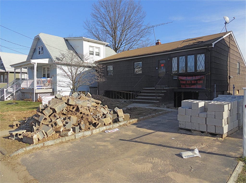
The effects of Hurricane Sandy on parts of Woodbridge are readily evident. Just take a drive in the Watson Avenue section of the township.
Months after the hurricane struck, homes are still unoccupied. You can see which ones by the bright orange stickers on the doors, labeling them unsafe for occupancy. You can see the gaping holes where solid foundations once stood.
What the future of the area will be after Hurricane Sandy, though, is still being pieced together.
Find out what's happening in Woodbridgewith free, real-time updates from Patch.
Two things are for certain: homes that have to be demolished will be rebuilt in a far different way then they originally were constructed, and homeowners who resist will pay a fortune in flood insurance premiums, if they can rebuld at all.
The Federal Emergency Management Agency (FEMA), which adminsters the National Flood Insurance Program (NFIP), is going to be asking for a lot more money from homeowners who defy their rebuilding codes. But that was changing in any case, said FEMA spokesman Robin E. Smith.
Find out what's happening in Woodbridgewith free, real-time updates from Patch.
"The increase in flood insurance premiums is tied to the flood insurance subsidies going away. Congress voted on that this last summer," Smith said in an email.
The maps of flood-prone areas were also being revised to incorporate new data before Sandy hit, Smith said. That included Woodbridge.
The maps, called Advisory Base Flood Elevations, or ABFEs, are produced following large storm events, such as Hurricane Sandy. According to FEMA documents, the agency "performs an assessment to determine whether the 1% annual chance flood event, shown on the effective FIRMs [Flood Insurance Rate Maps] adequately reflects the current flood hazard.
"In some cases, due to the age of the analysis and the science used to develop the effective FIRMs, FEMA determines there is a need to produce ABFEs. ABFEs are provided to communities as a tool to support them in recovering in ways that will make them more resilient to future storms," FEMA said in documents to help homeowners understand the implications of the new grading.
It's already taken place in the Watson Avenue section of the township. The street's base elevation has been increased from 9 feet to 13 feet above grade. That is something that residents who choose to rebuild will have to take into account.
Initially, according to FEMA documents, the township will have leeway about adopting the standards. But once the ABFEs are finalized, municipalities must revised their flood maps to reflect the new information, and that will affect residents in the area.
It will also have an effect on flood insurance premiums. For people whose homes weren't devastated enough to be rebuilt, their homes will remain the same but for one thing: their flood insurance premiums will go up.
In some cases, way up. Smith said that at this stage of the process, speculation about premium increases is just that - speculation.
FEMA gives an example of how the system will work in their flyer, Rebuilding After Sandy. The brochure strongly advises homeowners to "build correctly and higher" to mitigate flooding risk and save on flood insurance premiums in the bargain.
An example used in the flyer was of a home damaged or destroyed by flooding. The National Flood Insurance Program will require an additional four feet to be added to the current requirements, such as in the Watson Street example, where the elevation has been increased from 9 feet base flood elevation (BFE) to 13 feet.
In the FEMA example, a home that rebuilds at the 4 foot standard in the model will have $18,000 spent on its foundation, but will require a $31,500 annual flood insurance premium.
Homes built to 8 feet will spend more on the foundation - $29,000 in the example - but will save money on the flood insurance premium. In this case, it drops from $31,500 to $7,000.
Those who rebuild at an even higher elevation of 10 feet will spend $30,000 on the foundation, but spend only $3,500 on flood insurance premiums.
In the example, FEMA estimates the homeowners of the house built at a 10 feet will save $273,480 in premiums over a 10-year period.
"Flood insurance premiums are based on flood risk," FEMA states in the brochure. "Under new Federal law, flood insurance premium rates on many properties in special flood hazard zones will increase."
To find our your property's designation under the new FEMA flood maps, put your address into the FEMA chart on this link.
Follow Woodbridge Patch on Facebook, Twitter and sign up for the daily newsletter.
Get more local news delivered straight to your inbox. Sign up for free Patch newsletters and alerts.


